Lodgepole Campground Map at Sequoia National Park, California

Lodgepole Campground Map
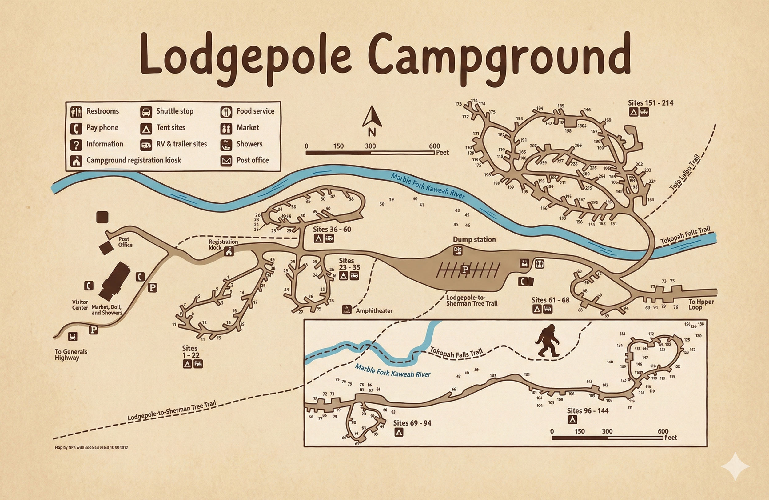
Lodgepole Campground Map — Sequoia National Park
Use this Lodgepole Campground map to understand loop layout, restroom icons, water spigots, bear lockers, river/trail access, and shuttle points—nothing but the map and how to read it.
Lodgepole Campground Map Overview
The Lodgepole Campground map highlights multiple one-way loops along the Middle Fork Kaweah River in Sequoia National Park. It clearly marks loop letters, site numbers, restroom icons, water spigots, bear lockers, and shuttle/visitor center access—so you can orient fast without skimming general park info.
Loops & Layout
Loops branch from the campground’s internal roads near the Lodgepole Visitor Center. River-side loops place you near footbridges and day-use areas; upper loops sit slightly farther from traffic with more forest cover. All interior roads are one-way; staying right naturally carries you around to each loop’s exit.
- River-adjacent loops: Fastest access to river viewpoints and footpaths.
- Forest/upper loops: Quieter feel, more shade, fewer passersby.
- Wayfinding: Track increasing site numbers to verify you’re circling the loop correctly.
Map Symbols & What They Mean
Look for these icons when scanning the Lodgepole map:
- Restrooms: Building icons spaced through loops (often near mid-loop junctions).
- Water Spigots: Faucet symbols along loop edges and near restrooms.
- Bear Lockers: Box icons by each site pad—store all food/scented items.
- Shuttle/Transit: Markers near the visitor center and hub areas.
- Trail/River Access: Paths to the river corridor and signed trail connections.
Mobile tip: zoom until restroom and faucet icons are clearly legible, then pan along road edges to follow site numbers in order.
Best Areas on the Map
- Near the river: Short walks to viewpoints and footbridges; soothing water sound.
- Interior forest loops: More privacy and shade; lighter foot traffic.
- Near restroom clusters: Most convenient for families—use icon clusters as landmarks.
Pick your vibe by loop letter and site range—the icons make convenience vs. quiet easy to spot.
Using the Map On-Site
Keep the map on your phone or print it before you arrive. At each junction, match the loop letter, follow one-way arrows, and track site numbers as they increase. Use restroom icons and the visitor center as “you-are-here” anchors before committing to a turn.
Lodgepole Campground Map FAQ
Can I use this map when I arrive at the campground?
Yes. It’s built for on-site navigation—match loop letters, follow one-way arrows, and use restroom icons and site numbers to orient quickly.
Does the map show restroom and water locations?
Yes. Restroom buildings and potable water spigots are clearly marked across loops.
Are loops one-way like they appear on the map?
Correct—interior roads are signed one-way. The arrows on the map reflect how you’ll drive each loop.
Where are the river and main facilities relative to the loops?
The river runs along the lower edge of several loops, with icons indicating footbridges and paths. The Lodgepole Visitor Center/shuttle hub sits near the main internal road.
See the Full Campground Guide
For campsite details and broader planning info, read our Lodgepole Campground Guide . This guide pairs with the map to help you orient loops and choose areas that fit your style.