The Best Campground Maps
CampChimp now makes campground maps! Most of our campground maps are for public campgrounds, but we’re happy to make free maps for private campgrounds too!
Do you want us to make you a free campground map? Contact us!
Arizona
Mather Campground Map
North Rim Campground Map
California
Black Rock Campground Map
Crane Flat Campground Map
D.L. Bliss Campground Map
Kalaloch Campground Map
Upper Pines Campground Map
Lodgepole Campground Map
Lower Pines Campground Map
Manzanita Lake Campground Map
North Pines Campground Map
Pfeiffer Big Sur Campground Map
Tuolumne Meadows Campground Map
Jumbo Rocks Campground Map
Colorado
Moraine Park Campground Map
Montana
Fish Creek Campground Map
Many Glacier Campground Map
St. Mary Campground Map
North Carolina
Smokemont Campground Map
Oregon
South Beach Campground Map
Tennessee
Cades Cove Campground Map
Elkmont Campground Map
Utah
Devil’s Garden Campground Map
Fruita Campground Map
South Campground Map
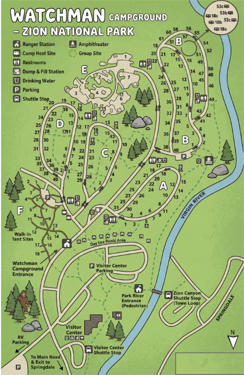
Watchman Campground Map
Wyoming
Bridge Bay Campground Map
Canyon Campground Map
Colter Bay Campground Map
Grant Village Campground Map
Jenny Lake Campground Map
Madison Campground Map
Campground Maps for Popular U.S. Campgrounds
Finding the right campsite can make or break a camping trip. That’s why CampChimp creates detailed, easy-to-read campground maps for some of the most popular state park, national park, and public campgrounds across the United States.
This page is your central hub for all of the campground maps we’ve created so far. Each map helps you understand campground layout, loop locations, site spacing, road access, and proximity to key features like restrooms, beaches, trails, and scenic viewpoints—before you book.
Why Campground Maps Matter When Camping
Official campground reservation pages often show availability but don’t always make it easy to visualize where sites are actually located. A good campground map helps you:
Choose quieter or more private campsites
Avoid sites near restrooms, roads, or generators
Find sites closer to water, trails, or scenic views
Understand campground loops and traffic flow
Book with confidence instead of guessing
Our goal is to make campground layouts easier to understand so you can pick the best site for your camping style—whether you’re tent camping, RV camping, or traveling with kids.
What You’ll Find in Our Campground Maps
Each CampChimp campground map is designed to be clear, practical, and mobile-friendly. Depending on the campground, maps may show:
Campsite numbers and campground loops
Roads, entrances, and exits
Restrooms, showers, and dump stations
Walk-in sites vs. drive-in sites
Beach, river, or lake access points
Trailheads and nearby points of interest
We focus on the information campers actually need when deciding where to stay, not just if something is available.
can You Make Me a Campground Map for Free?
Yes! We are more than happy to make you a free campground map! Just contact us and we’ll give you more information.
Campground Maps by Location
Below you’ll find a growing list of campground maps we’ve created across national parks, state parks, and public lands. We’re constantly adding new campground maps as we expand coverage, so check back often if you don’t see your destination yet.
If you’re planning a camping trip and want to quickly understand campground layout before booking, this is the best place to start.
Built for Tent Campers, RV Campers, and Families
CampChimp campground maps are designed for all types of campers, including:
Tent campers looking for quieter, more private sites
RV campers who need to understand road access and loop design
Families trying to stay close to bathrooms or playgrounds
Campers who want scenic views or quick trail access
No matter how you camp, a clear campground map helps you make a smarter choice.
More Campground Maps Coming Soon
We’re actively building one of the largest online libraries of campground maps in the U.S. If there’s a campground you’d like us to map next, chances are it’s already on our list.
Bookmark this page or check back as we continue adding new campground maps to help you plan better camping trips—without the guesswork.