Upper Pines Campground Map at Yosemite, California

Yosemite Upper Pines Campground Map
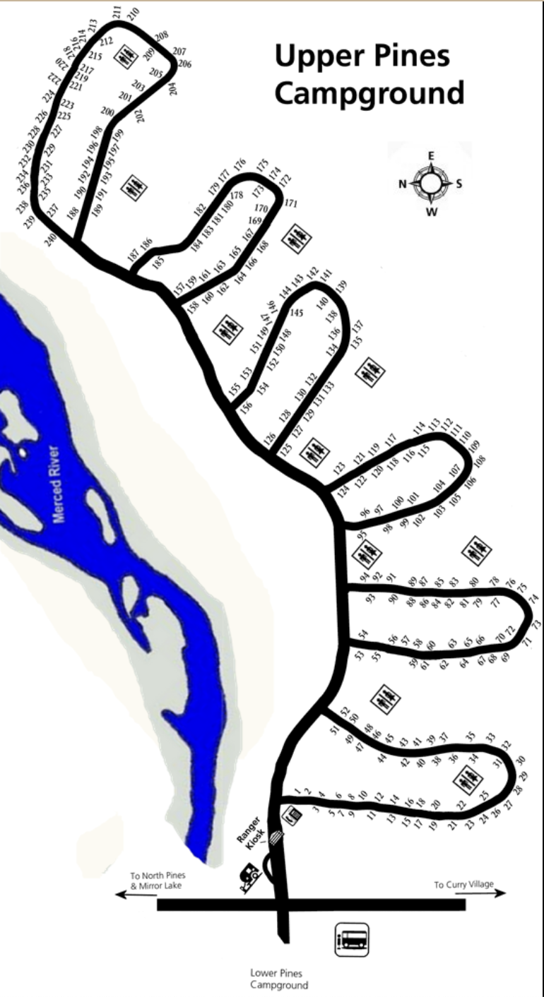
Upper Pines Campground Map — Yosemite National Park
Use this Upper Pines Campground map to understand the loop layout, restroom icons, water spigots, bear boxes, and shuttle access—nothing but the map and how to read it.
Upper Pines Campground Map Overview
The Upper Pines Campground map highlights the six loops (A–F), numbered 238 campsites, and the core amenities you’ll find on-site. It’s designed to help you quickly spot restrooms, potable water spigots, bear-proof food lockers, and shuttle access without digging through general park details.
Loops & Layout (A–F)
The campground is a set of one-way loops branching from the internal road system. Loops A–C sit closest to Curry Village and the shuttle corridor, while Loops D–F extend toward the Merced River and usually feel quieter with more shade. Follow loop arrows on the map; staying right will naturally carry you around each semicircle of sites.
- Loop signs: Letters (A–F) appear near junctions and on the map legend.
- Site numbers: Increase sequentially along each loop—use them to estimate distance to the next restroom icon.
- One-way flow: Plan turns ahead; you’ll exit the same way you entered after completing a loop.
Icons on the Map (How to Read Them)
The map marks essentials with easy symbols so you can navigate by sight:
- Restrooms: Clustered about every 40–50 sites, often near loop junctions.
- Potable Water: Spigots along loop edges; look for short spigot icons near pullouts.
- Bear Boxes: At almost every site—icons indicate locker placement relative to the pad.
- Shuttle Access: Marked at the campground entrance; use it to connect to valley trailheads without moving your vehicle.
Tip: If you’re scanning on a phone, zoom until loop letters and restroom icons are clear, then pan along the road edge to follow site numbers in order.
Best Areas on the Map
- Riverside (E & F): Typically quieter and most shaded; quick access to the Merced River.
- Central (around D): Balanced walking distance to restrooms and the main road.
- Entrance (A–B): Fastest in/out and easy wayfinding; shortest walk to the shuttle stop.
These areas are based on layout only—use the map’s loop letters, site ranges, and icons to pick your preferred vibe on arrival.
Using the Map On-Site
Keep the map handy on your phone or print it before you leave service. On arrival, match the loop letter on the ground to the loop letter on the map. Follow the one-way arrows, track site numbers in sequence, and use restroom icons as reference points to confirm you’re moving in the right direction.
Upper Pines Campground Map FAQ
Can I use this map when I arrive at the campground?
Yes. It’s designed for on-site navigation—match loop letters, follow the one-way arrows, and use restroom icons and site numbers as your landmarks.
Does the map show restroom and water locations?
Yes. Restroom icons appear in each loop, and potable water spigots are marked along the loop edges.
Are the loops one-way, and are they labeled A–F on the map?
Yes. All loops are one-way, and each loop is clearly labeled A through F on the map and at campground junctions.
Which areas are quietest based on the map?
Loops E–F toward the Merced River generally feel quieter and more shaded, while A–B near the entrance are busier but offer the quickest access to the shuttle.