Manzanita Lake Campground Map at Lassen Volcanic National Park, California

Manzanita Lake Campground Map
Manzanita Lake Campground Map — Lassen Volcanic National Park
Use this Manzanita Lake Campground map to understand the loop layout, restroom icons, water spigots, bear lockers, and trail access — nothing but the map and how to read it.
Manzanita Lake Campground Map Overview
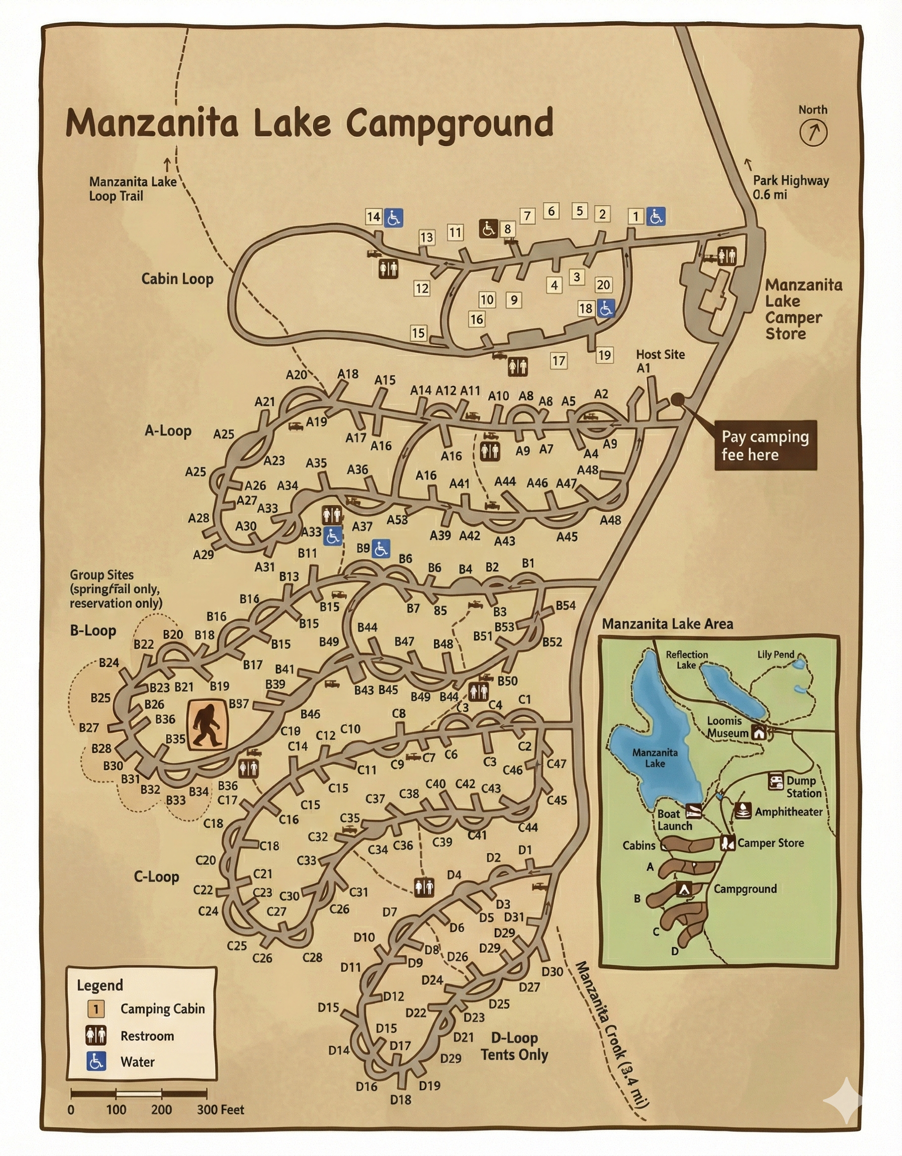
The Manzanita Lake Campground map outlines seven main loops spread through a ponderosa pine forest near the north entrance of Lassen Volcanic National Park. The map highlights 179 campsites, including standard, group, and RV sections, all within walking distance of Manzanita Lake and the visitor center.
Loops & Layout
The campground is divided into Loops A–G, each shown clearly on the map. Loops A–C circle closest to Manzanita Lake and offer the shortest walk to the lake trail and general store. Loops D–F are set farther back among mature pines, offering more shade and privacy. Loop G sits near the group and RV area with easier vehicle access.
- Loop A–C: Lake proximity, quick access to store, amphitheater, and trailhead.
- Loop D–F: Forested and quiet, ideal for tent campers seeking shade.
- Loop G: Near group sites and RV spurs; easy access for larger rigs.
Map Symbols & Icons
The map uses simple icons to mark key amenities:
- Restrooms: Buildings marked across loops, roughly one per 25–30 sites.
- Water Spigots: Faucet icons along main roads and loop junctions.
- Bear Lockers: Box symbols beside each site pad; every site has one.
- Trailheads: Dashed lines leading to Manzanita Lake Trail and Lassen Peak Highway.
- Dump Station: Located at the campground entrance; shown on the map’s left edge.
Tip: Print or download the map before arrival — cell coverage near the lake is limited, and loops can look similar after dark.
Best Areas on the Map
- Lake Loops (A–C): Closest to Manzanita Lake and the trailhead — best for early-morning paddlers and photographers.
- Forest Loops (D–F): Shadier and quieter, great for tent campers and families wanting less foot traffic.
- Upper Loop (G): Easiest for RVs and group access, plus quick exit to Lassen Peak Highway.
Manzanita Lake Campground Map FAQ
Can I use this map when I arrive at the campground?
Yes. The map matches the current campground layout and works well for on-site navigation.
It’s helpful to print or save a copy before arriving since Wi-Fi and service are limited inside Lassen.
Does the map show restroom and water locations?
Yes. Restroom icons appear in each loop, and water spigots are marked along loop roads.
Are the loops one-way like they appear on the map?
Yes. All loops are one-way and marked accordingly on the campground signage and map.
Which loops are nearest the lake according to the map?
Loops A, B, and C border Manzanita Lake and offer the shortest walk to the shoreline and day-use area.
See the Full Campground Guide
For campsite details, booking tips, and visitor info, check out our Manzanita Lake Campground Guide . It pairs perfectly with this map to help you plan your stay in Lassen Volcanic National Park.