Jumbo Rocks Campground Map at Joshua Tree National park, california

Jumbo Rocks Campground Map at Joshua Tree National Park
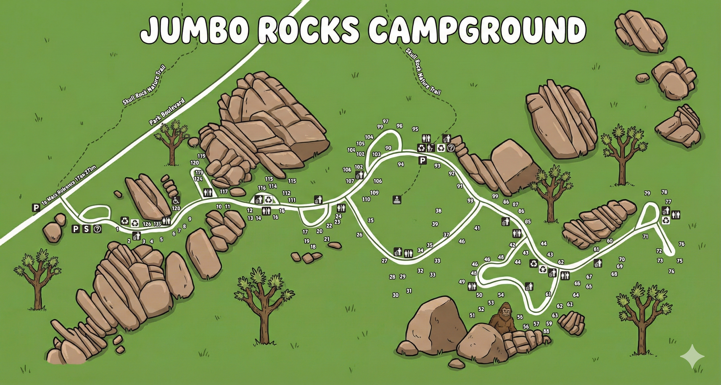
Jumbo Rocks Campground Map Overview
The map shows a single, curving campground road looping away from Park Boulevard and weaving through stacks of rock outcrops. Park Boulevard runs across the top of the map, with arrows to the West Entrance on the left and North Entrance on the right. The Skull Rock Nature Trail parallels the road as a dashed line.
Campsites are numbered from roughly 1–124 along the loop road and a few short spurs. Black icons mark restrooms, drinking water, and trash receptacles, while special symbols highlight the picnic area, amphitheater, and nature trail connections.
Campsite Layout Around the Loop
Jumbo Rocks is essentially one long, one-way loop with a few side fingers:
- Western entrance area (sites 1–16): Just off Park Boulevard near the main parking cluster for sites 1–4 and the trash / fee icons. Site numbers 5–16 then wrap around the first big rock pile.
- Central corridor (sites 17–50s): As the road bends east, sites 17–39 sit on the outside of the curve facing rock formations, with 20s and 30s along the inner side. Further along, sites 40–55 continue south where the loop dips down.
- South loop pocket (sites 25–35 & 50–60s): The deepest part of the loop is a bulb around sites 25–35, 34–38, and 50–60, with restrooms and water near site 34. This pocket is what most people picture as the “main” Jumbo Rocks bowl.
- Eastern leg & spurs (sites 61–79): Heading back up, sites 61–72 line the road, with a spur to sites 71–79 tucked into rocks on the far east side of the map.
- Northern arc (sites 80–124): The return leg toward Park Boulevard holds sites 80–99 and 100–124, mostly on the outside of the road with large boulder stacks directly behind them. A parking icon and cluster of facilities appear around sites 93–98.
Since the loop is long and narrow, site numbers are your main orientation tool—follow them in order and you always know which direction you’re heading around the circle.
Facilities & Icons on the Jumbo Rocks Map
The legend at the bottom of the map uses simple icons you’ll see repeated along the road:
- Restrooms: Toilet icons appear near the entrance cluster, around sites 34–36, near sites 86–88, and by the eastern spur at sites 77–79.
- Drinking water: Cup icons near the main parking area, the central restroom cluster, and the eastern end of the loop.
- Trash receptacles & recycling: Trash can and recycle icons grouped with restroom clusters so you can combine bathroom and trash runs.
- Picnic area: Picnic-table icon near the main parking zone along Park Boulevard.
- Amphitheater: Amphitheater symbol in the central bowl of the loop for ranger talks and night sky programs.
- Parking: “P” icons at the main entrance and the mid-loop parking pad east of site 93.
None of the sites themselves have hookups; all shared services (water, trash, restrooms) are in these small bundles, so it’s worth noting which cluster you’ll walk to most often.
Rock Formations & Nature Trails
The shaded shapes all around the loop represent the huge rock piles that give Jumbo Rocks its name. Many sites back directly up to boulders, which you can see by the rocks drawn right behind the site numbers.
Along Park Boulevard, the dashed Skull Rock Nature Trail connects the campground to Skull Rock and other viewpoints. Several trail icons and dashed paths drop from the loop road up toward the trail, so you can walk out without moving your car.
Jumbo Rocks Campground Map FAQ
How many sites are shown on the Jumbo Rocks map?
The map labels sites from 1 through the 120s, all along one extended loop road with a few short spurs.
Does the map show water and restrooms?
Yes. Restroom icons and drinking-water symbols appear at several points around the loop—near the entrance, in the central bowl,
around sites 86–88, and by the eastern spur near sites 77–79.
Where is the amphitheater?
The amphitheater icon is placed in the central portion of the loop, near the cluster of sites in the 30s where the road dips south.
How do I reach Skull Rock from the campground?
Follow one of the trail icons leading from the loop road up to the dashed Skull Rock Nature Trail along Park Boulevard,
then head east toward the Skull Rock area as shown on the map.