Map of North Pines Campground at Yosemite National park, california

Map of North Pines Campground at Yosemite National Park
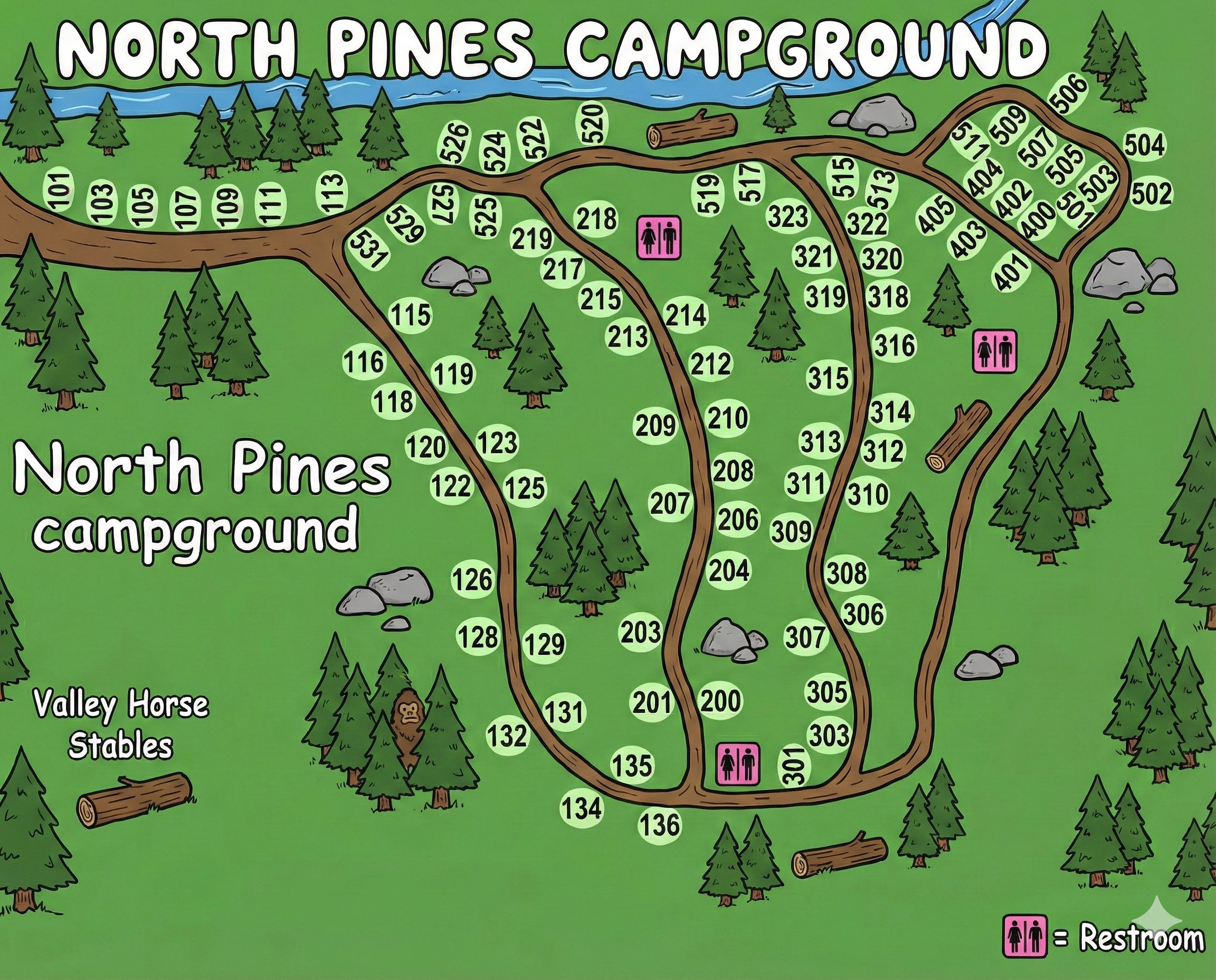
North Pines Campground Map Overview
North Pines sits at the east side of Yosemite Valley on a narrow peninsula formed by the Merced River to the north and Tenaya Creek to the east. The road enters from the west, passes the Valley Horse Stables, and splits into three branching campground loops.
Campsites are numbered mostly in the 100s, 200s, 300s, and 500s, with restroom icons represented as bright pink squares on the map. The rivers provide natural boundaries that help you orient yourself— water above and to the right, stables to the left.
Campground Layout Between the Rivers
The road system resembles a three-fingered fork:
- The main road enters and immediately curves north, skirting the Merced River where sites 101–111 line the shoreline.
- Three interior spurs extend south and east into the peninsula, serving sites in the 200s and 300s.
- A smaller upper spur branches toward the 500-series sites (501–525), tucked against the Merced River bend.
- Tenaya Creek borders the entire east side; sites in the low 300s sit closest to the water.
Using water boundaries—river to the north, creek to the east—is the easiest way to stay oriented in this compact layout.
Loops & Numbered Site Clusters
The map organizes sites into natural clusters rather than named loops:
- Riverside sites (101–111): Hug the Merced River near the entrance. These are the quickest to access.
- Central peninsula (115–136 & 200–225): Two branching arms hold mid-range numbers, curving between trees and boulders.
- Lower peninsula (300–318): Sites cluster near the Tenaya Creek edge with a restroom icon near site 301.
- Upper spur (400s & 500s): The 401–409 and 500–513 loops sit near the river bend, with the 520s marking the northernmost pads.
Site numbers climb roughly from west to east, with 500s appearing on their own small loop.
Restrooms & Key Landmarks on the Map
North Pines’ map uses pink squares to mark restroom locations. They appear in three strategic spots:
- Near sites 116–119 in the central fork.
- Near sites 314–318 on the Tenaya Creek side.
- Near site 301 close to the south loop.
Additional map labels include:
- Valley Horse Stables west of the entrance road.
- Merced River forming the campground’s entire northern border.
- Tenaya Creek defining the east boundary.
- Directional N arrow at the southwest corner.
How to Use the Map When You Arrive
A reliable navigation method at North Pines:
- Confirm your site number and identify which numbered cluster it falls into.
- Use the rivers as orientation anchors—Merced River above, Tenaya Creek to your right as you drive in.
- Follow the branching one-way patterns until your site number shows up in sequence.
- Locate the nearest pink restroom icon and note your walking path for nighttime use.
Because the campground is compact, most sites are within a short walk of at least one restroom building.
North Pines Campground Map FAQ
How many clusters does the map show?
Four main groups: 100s along the river, 200s and low 300s in the center, 300s near Tenaya Creek, and 400/500s on the upper spur.
Does the map show restroom locations?
Yes—pink squares appear near the 100s/200s junction, the south loop, and the 300s near Tenaya Creek.
How do I know which direction is north?
A black N arrow sits at the bottom-left corner, pointing diagonally upward.
Are the rivers good orientation markers?
Absolutely. Merced River borders the top of the campground and Tenaya Creek borders the right side.