Fish Creek Campground Map, Glacier, Montana

Fish Creek Campground Map
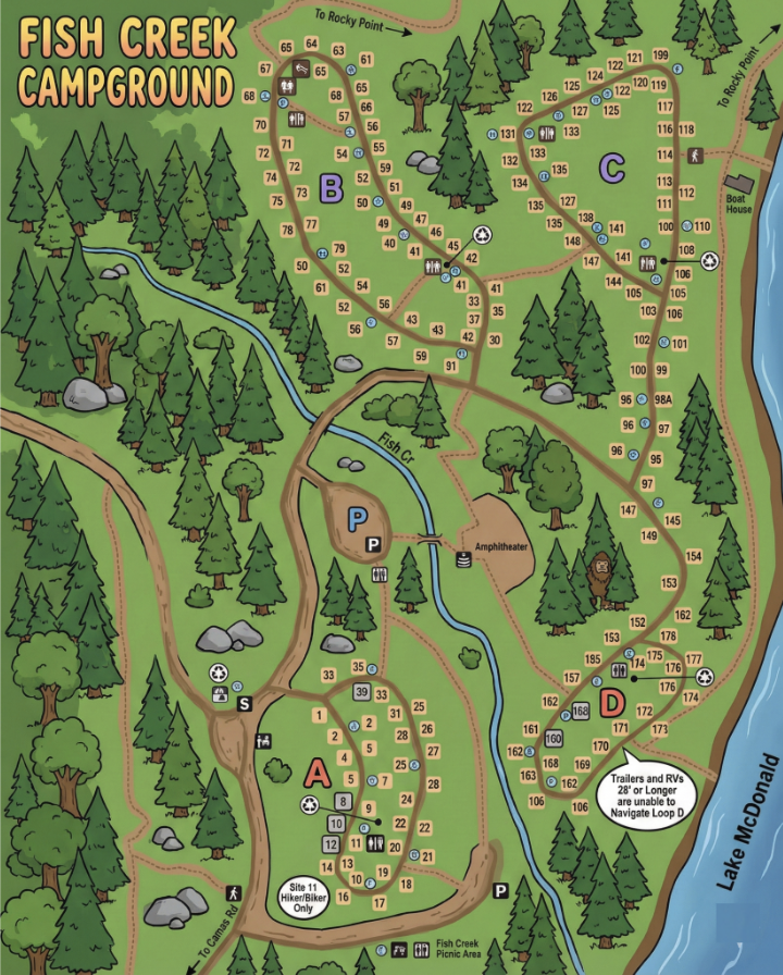
This is a map-only guide to Fish Creek Campground in Glacier National Park. It’s built to help you read the campground layout fast: loop letters, site numbering, where RV/trailer-friendly areas sit, and how the campground connects to the lakeshore and nearby roads.
- Loops are lettered A–D on the map.
- Lake McDonald is on the right side (east) of the map.
- The internal road network branches into distinct loop “neighborhoods” rather than one continuous circle.
Layout by Loop (A–D)
Fish Creek is divided into four lettered sections. Each loop has its own internal road pattern and site clusters:
Loop A contains many lower-numbered sites and includes a clearly labeled hiker/biker-only area near the bottom of the loop.
Loop B sits above Loop A and forms a compact loop with many sites arranged tightly around the road.
Loop C runs closest to the Lake McDonald side of the map and stretches in a longer shape with many numbered sites along its edges.
Loop D is the lower-right cluster near the lakeshore and includes a note about trailers and RVs (see below).
Campsite Numbers (How to Find Your Site)
Site numbers are printed along the road edges inside each loop. The practical way to use this map: identify your loop letter first, then follow the road line visually until you hit your site number.
- Loop A shows many lower numbers and the hiker/biker area.
- Loops B–C include dense clusters where zooming in (or printing) makes site numbers much easier to follow.
- Loop D numbers run around the loop near the “trailers/RVs” note.
Facilities & Map Symbols
Fish Creek’s map uses standard campground symbols for key stops and services. Use these as anchors when you’re trying to figure out where you are in the loop system.
- Restrooms: Marked by restroom icons within the loop areas.
- Parking (P): Marked in multiple locations, including near the central internal roads.
- Amphitheater: Labeled near the middle of the campground road network.
- Picnic area: Labeled as Fish Creek Picnic Area near the bottom edge of the map.
- Road/trail connectors: Dotted lines indicate footpaths connecting areas and/or heading toward points outside the campground.
Trailers & RVs (Map Note)
The map includes a specific note near Loop D indicating that trailers and RVs (with length guidance shown on the map) are allowed and that you should use the main campground road to reach Loop D.
If you’re towing, treat that note as your routing instruction: enter, stay on the main campground road, then branch into Loop D from the correct direction.
Fish Creek Campground Map FAQ
How is Fish Creek organized?
The campground is divided into Loops A, B, C, and D, each with its own cluster of sites.
Which side of the map is Lake McDonald?
Lake McDonald is shown on the right side of the map, next to Loops C and D.
Is there a hiker/biker-only area?
Yes. The map labels a Hiker/Biker Only section within the Loop A area.
Where does the map mention RVs and trailers?
Near Loop D, the map includes a note about trailers and RVs and how to navigate to that loop.