Tuolumne Meadows Campground Map at Yosemite National Park, California

Tuolumne Meadows Campground Map at Yosemite
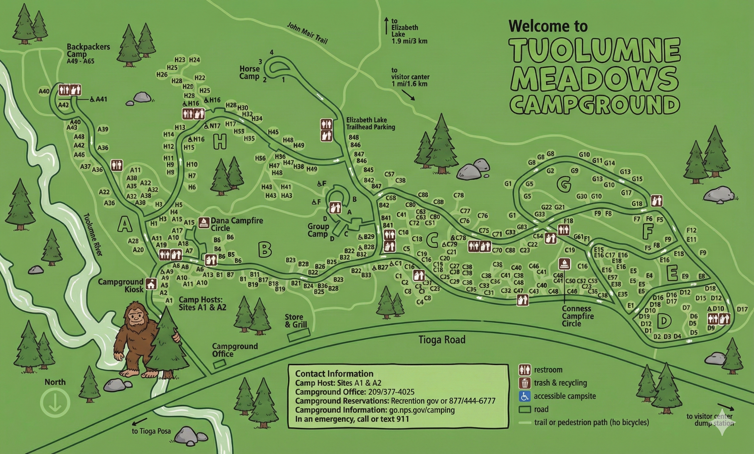
Tuolumne Meadows Map Overview
The map shows Tuolumne Meadows Campground stretched between the Tuolumne River and Tioga Road at high elevation on Yosemite’s east side. Campsites are grouped into loops labeled A through H, each with numbered pads (for example A1–A45, C1–C89, etc.). A north arrow at the bottom points down, so the river and backpackers camp sit toward the left/top of the map while Tioga Road runs along the bottom.
Contact information is printed in a gray box near the bottom, and arrows show where Tioga Road heads toward Tuolumne Meadows visitor center, the dump station, and Tioga Pass.
Loop Layout & Road Flow
All of the main camping areas sit above Tioga Road, connected by one primary entrance road that splits into the lettered loops:
- Loop A: Closest to the entrance, between the Tuolumne River and the road to the Campground Kiosk.
- Loop B: Just uphill from A, wrapped around the Dana Campfire Circle with several restroom icons.
- Loop C: Large cluster along the center-right of the map around the Conness Campfire Circle.
- Loop D: Compact loop near the bottom-right corner of the campground, just above Tioga Road.
- Loops E & F: Smaller loops on the right side, sharing trails and facilities with Conness Campfire Circle.
- Loop G: The big outer loop to the north-east, encircling a wide oval of sites and its own restroom/trash icons.
- Loop H: A long loop that arcs up toward Horse Camp 2 and ties back into the interior road near B and C.
Roads are shaded in dark gray on the map. Following them in order keeps you from getting turned around between loops, especially at the junctions near Dana and Conness Campfire Circles.
Trails, Campfire Circles & Special Areas
Dashed lines mark trails or pedestrian paths (no bicycles), and they connect several key features:
- Backpackers Camp (A45–A65): A separate cluster of sites beyond Loop A, along the river, reached by a trail rather than the main road.
- Horse Camp 2: Small spur above Loop H with a couple of numbered horse camp sites.
- Dana Campfire Circle: Central campfire program area near the junction of loops A, B, and H.
- Conness Campfire Circle: Another program area set between loops C, E, and F.
- Elizabeth Lake Trailhead Parking: Marked up near loops E and G, with an arrow toward Elizabeth Lake (1.9 mi / 3 km).
- John Muir Trail: A dashed corridor running behind parts of the campground, showing how close long-distance hiking is to some sites.
If evening ranger talks or early-morning hikes are on your list, choose sites that sit close to the appropriate campfire circle or trailhead symbols.
Facilities Icons on the Tuolumne Map
The legend in the lower right corner keeps the icons simple:
- Restroom: Small toilet icons scattered around nearly every loop.
- Trash & recycling: Paired can/recycle symbols clustered near restrooms and road junctions.
- Accessible campsite: Tent symbols with an accessibility marker next to certain sites.
- Road: Dark gray bands that form the vehicle loops.
- Trail or pedestrian path: Dashed lines that weave between loops, the river, and trailheads.
Near Tioga Road you’ll also see icons and labels for the campground office, store & grill, and contact information box—handy if you need help outside normal kiosk hours.
Areas to Target on the Map
- River-adjacent sites in Loop A: Short walk to the Tuolumne River and backpackers camp, good for scenery and sound of water.
- Central loops B & C: Close to Dana and Conness Campfire Circles with multiple restrooms and trash stations.
- Loops E, F & G: Convenient if you want quick access to the Elizabeth Lake Trailhead and upper trails.
- Loop H near Horse Camp: Feels a bit more tucked away toward the back of the campground while still on the main road network.
These preferences are based purely on what the map shows—distance to facilities, proximity to trails, and general layout—not on individual site quality.
Tuolumne Meadows Campground Map FAQ
Does the map show all the loops and site numbers?
Yes. Loops A through H are clearly labeled, and every campsite has a letter-and-number label printed next to the pad.
Can I see where the trails connect from the campground?
The map marks the John Muir Trail, paths to Elizabeth Lake Trailhead, and pedestrian routes around the river and campfire circles.
Where are the restrooms and trash/recycling?
Restroom and trash & recycling icons are spread across all loops, usually near junctions so several clusters of sites can share them.
Is the backpackers camp shown?
Yes. A labeled “Backpackers Camp A45–A65” sits beyond Loop A along the Tuolumne River, reached by trail rather than vehicle road.