Moraine Park Campground Map at Rocky Mountain, Colorado

Moraine Park Campground Map at Rocky Mountain
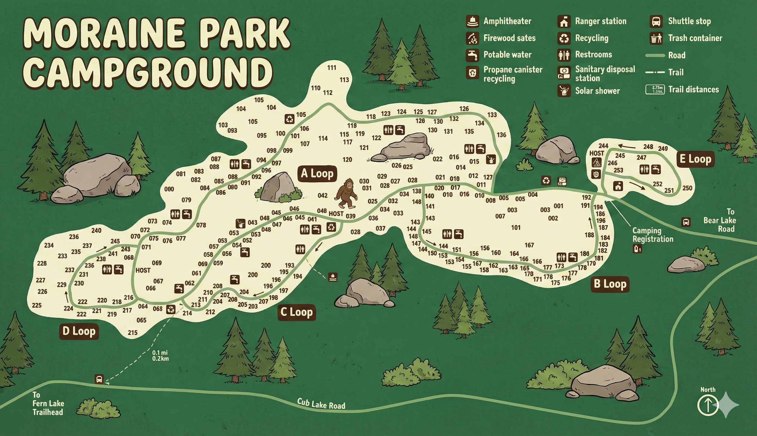
Moraine Park Campground Map Overview
The map shows Moraine Park Campground perched on the hillside above Cub Lake Road, with a series of lettered loops: D Loop and C Loop toward the west end, A Loop stretched across the center ridge, B Loop down near camping registration, and E Loop on its own spur toward Bear Lake Road.
Campsites are numbered (001–253 range) and printed along the loop roads. Icons mark restrooms, potable water, trash containers, firewood sales, amphitheater, ranger station, recycling, sanitary disposal, solar showers, and shuttle stops.
Loop Layout: A, B, C, D & E
From west to east, the loops step along the hillside:
- D Loop: Westernmost loop above Cub Lake Road, holding sites in the 220s–240s range. A host site and restroom sit near the entrance, with additional sites stretching out toward the edge of Moraine Park.
- C Loop: Just uphill from D, a compact loop of sites 190–215 or so. Restroom and potable water icons sit at the middle of the loop, plus a trail leading down toward Cub Lake Road.
- A Loop: Longest loop running across the center of the map. Sites 040–136 line both sides of the ridge road, broken into clusters with several restrooms, water spigots, and trash containers along the way. A host site sits around 039.
- B Loop: Lower-right loop near the Camping Registration building. Sites 160–189 wrap around a short oval with restrooms and water close to the center.
- E Loop: Separate spur off the main access road toward Bear Lake Road, with sites 244–253 around a tight circle and a host site at its entrance.
All loops are one-way or low-speed. If you pass your site number, keep following the loop until you circle back toward it—no need for tight U-turns on the hill.
Facilities & Icons on the Moraine Park Map
The legend packs in a lot of detail:
- Restrooms: Toilet icons sprinkled through A, B, C, D, and E loops, usually close to clusters of water spigots.
- Potable water: Faucet icons along the main loop roads so most sites are only a short walk away.
- Trash & recycling: Trash can and recycling icons at several junctions and near the camping registration area.
- Sanitary disposal station: Holding-tank icon along the access road, serving RVs for the campground.
- Firewood sales: Log icon in the central section of A loop where you can buy firewood.
- Solar shower: Special shower icon shown near one of the restroom clusters.
- Ranger station & amphitheater: Icons near the east side of the campground and toward the west near D loop, marking where you’ll find ranger programs and evening talks.
When choosing a site, use the map to balance views and distance to services—A loop has the most facilities, while C and D loops tend to feel a bit more tucked away.
Road Access, Trails & Shuttle Stops
The bottom of the map shows Cub Lake Road with a shuttle stop icon and arrows: one direction leads “To Fern Lake Trailhead,” while another toward the east points “To Bear Lake Road.”
Dotted trails climb from Cub Lake Road up through C and D loops toward the campground, with distances labeled (0.1 mi / 0.2 km segments). Internal trails also connect parts of A loop to facilities and viewpoint spots.
Moraine Park Campground Map FAQ
Which loops are shown on the Moraine Park map?
The map shows five loops: A, B, C, D, and E, plus host sites and the central camping registration area.
Does the map mark restrooms and water?
Yes. Each loop has restroom icons and nearby potable water spigots so all sites are within walking distance of facilities.
Where is the sanitary dump station?
A sanitary disposal station icon appears along the main access road leading toward the campground, accessible for RVs leaving or arriving.
Can I see trail and shuttle connections on the map?
The bottom edge shows Cub Lake Road with a shuttle stop and arrows to the Fern Lake and Bear Lake areas, plus dotted trails leading
from the campground down to the road.