Fruita Campground Map, Capitol Reef, Utah

Fruita Campground Map
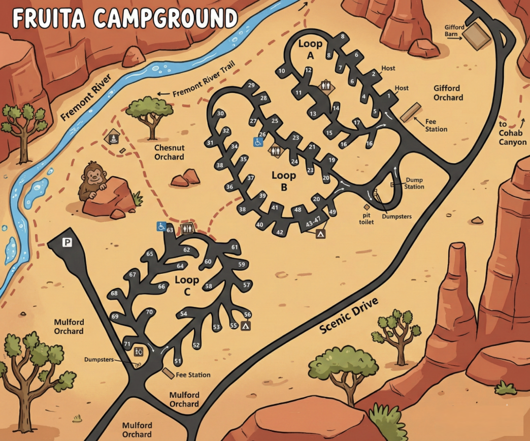
Fruita Campground Map Overview
Fruita Campground is arranged as three connected loops branching off Scenic Drive. The map shows a clear separation between loops while still making it easy to understand how everything ties together via short connector roads and footpaths.
If you know your loop letter first, navigation is straightforward — each loop is visually distinct and clearly labeled.
Campground Loops
- Loop A: Closest to Gifford Orchard, with host sites and a fee station nearby.
- Loop B: The central loop, connecting most directly to internal paths and shared facilities.
- Loop C: Southern loop near Mulford Orchard, with its own fee station and dumpster area.
All three loops are one-way as shown on the map, which helps reduce congestion but makes knowing your site number important before entering.
Campsite Numbers
Campsites are numbered sequentially within each loop rather than across the entire campground. The map clearly clusters site numbers around each loop roadway, making it easy to visually identify whether a site is on an inside curve, outer edge, or near a connector road.
When arriving, match both the loop letter and the site number — relying on one without the other can send you in the wrong direction.
Facilities & Map Icons
- Camp hosts: Marked near Loop A and Loop B.
- Restrooms: Shown with standard restroom icons near central areas.
- Dump station: Located along the main internal road near Loop B.
- Fee stations: Shown near Loop A and Loop C entrances.
- Dumpsters: Placed at the edges of loops to reduce through traffic.
- Accessible sites: Marked with wheelchair icons on the map.
Trails, Orchards & Nearby Features
The map highlights several features that make Fruita unique:
- Fremont River Trail: Shown along the river, with footpath connections from the campground.
- Gifford Orchard: Located near Loop A.
- Chestnut Orchard: Shown north of Loop B.
- Mulford Orchard: Adjacent to Loop C.
- Scenic Drive: Main access road running along the east side of the campground.
Fruita Campground Map FAQ
How many loops does Fruita Campground have?
Three — Loop A, Loop B, and Loop C.
Are loops clearly separated?
Yes. Each loop is visually distinct on the map and accessed via short connectors off the main internal road.
Does the map show nearby trails?
Yes. The Fremont River Trail and footpaths to orchard areas are clearly marked.
Is there more than one fee station?
Yes. Fee stations are shown near Loop A and Loop C.