Map of Devil’s Garden Campground, Arches, Utah

Devil’s Garden Campground Map
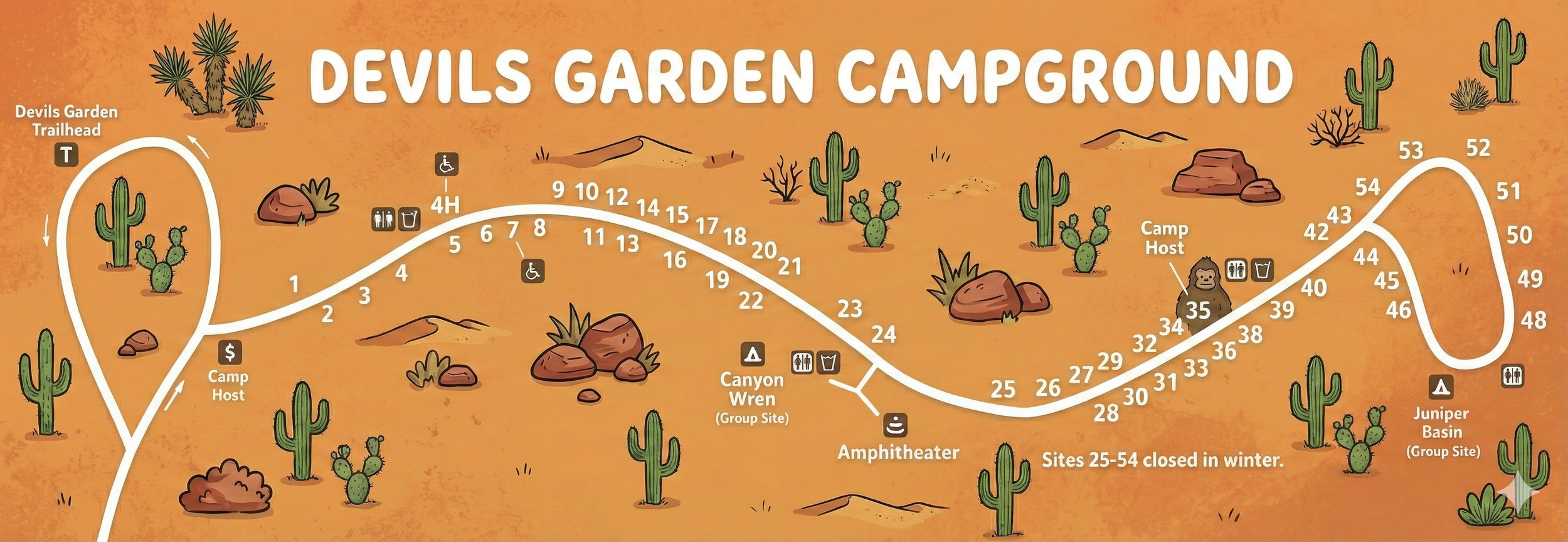
Devils Garden Campground Map Overview
The campground is drawn as a single main drive that starts near the entrance, runs east-west across the map, and ends at a large turnaround loop near the Devils Garden Trailhead. Campsites are numbered consecutively along the road, with small icon clusters showing restrooms, water, and other services.
The simplest way to use this map: find your site number, then trace the road in order—there aren’t multiple named loops to choose from, just one main route.
Road Layout From Entrance to Trailhead Loop
Devils Garden Campground is organized like a long ribbon:
- Entrance / early sites: Site numbers begin at the start of the road and increase as you drive deeper into the campground.
- Mid-camp spine: The road gently bends through the central sites, passing multiple facility icons and a signed group area.
- End loop (trailhead turnaround): The road finishes in a big loop adjacent to the Devils Garden Trailhead.
If you miss your site, you typically need to continue forward until a safe turnaround point—so it helps to know whether your number is in the teens, 20s, 30s, or 40s/50s.
Campsite Numbers (1–54)
The map shows numbered sites running from 1 near the entrance end up to 54 near the far end loop. A practical way to think about the layout:
- Sites 1–24: Earlier along the main drive, before the amphitheater area.
- Sites 25–39: Mid-to-late stretch where the road straightens and then climbs toward the host and facility cluster.
- Sites 40–54: Final approach into the end loop, closest to the Juniper Basin group area and the trailhead turnaround.
Facilities & Key Labels Shown on the Map
Devils Garden’s map uses icons and labels rather than a long legend. Notable map features include:
- Camp host: Marked near the early part of the campground and again near the higher-numbered end of the road.
- Restrooms & water: Shown in small clusters along the main drive (especially around the mid-camp area).
- Amphitheater: Labeled near the middle of the campground, useful as a navigation landmark even if you’re not attending programs.
- Group sites: Canyon Wren (Group Site) appears near the amphitheater area; Juniper Basin (Group Site) is near the end loop.
- Devils Garden Trailhead: At the far-left turnaround loop—this is the “end of the road” anchor on the map.
Seasonal Note on This Map
Devils Garden Campground Map FAQ
Is this campground made up of multiple loops?
Not really. The map shows a single main campground road with spur-like site pads, ending in a large turnaround loop near the trailhead.
Where is the Devils Garden Trailhead relative to campsites?
It sits at the far end of the campground at the big loop/turnaround—sites in the 40s and 50s are closest on the map.
Does the map show group areas?
Yes. The map labels Canyon Wren (Group Site) near the amphitheater and Juniper Basin (Group Site) near the end loop.
Are any sites closed seasonally?
Yes—the map explicitly notes that sites 25–54 are closed in winter.