Map of Crane Flat Campground, Yosemite, california

Map of Crane Flat Campground
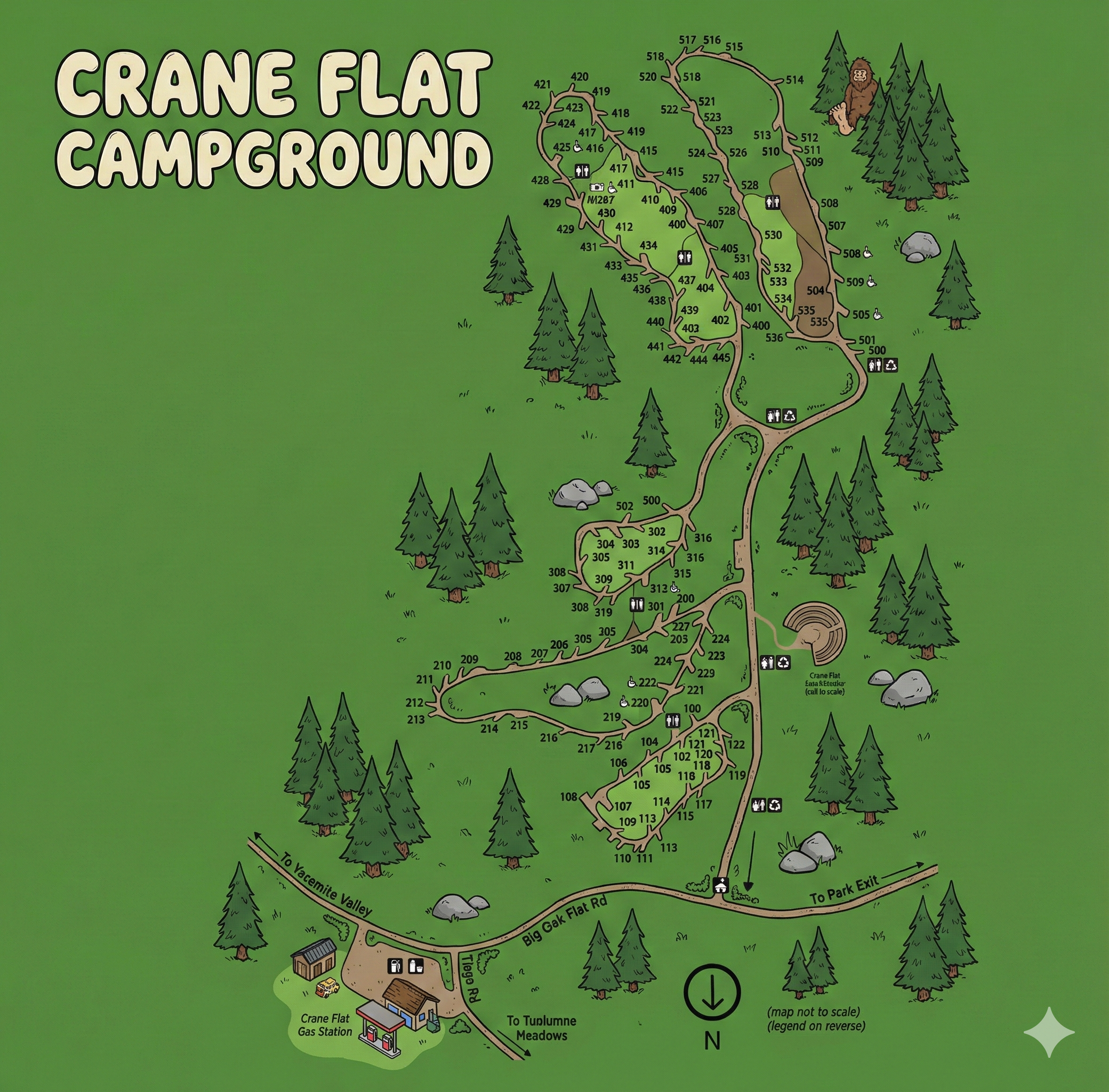
Crane Flat Campground Map Overview
The campground branches off Big Oak Flat Road near the signed junctions that point “To Yosemite Valley,” “To Tuolumne Meadows,” and “To Park Exit.” The internal campground road climbs northward from the entrance and feeds several spur loops with campsite numbers in distinct blocks (100s, 200s, 300s, 400s, 500s).
The map’s orientation arrow shows north pointing downward (as drawn), so use road labels—especially Big Oak Flat Road and the marked park/valley directions— as your primary anchors.
Road Shape & How the Campground Is Organized
Crane Flat is essentially a long central access road with loop spurs:
- Entrance & lower hub: Closest to Big Oak Flat Road, with the first campsite clusters and a small set of service icons nearby.
- Mid-camp spurs: A left spur serves a compact group of 200-series sites, while the main road continues to 300-series loops.
- Upper loops: The largest concentration is at the top of the map where 400- and 500-series sites loop around a host location and restroom icons.
- Amphitheater spur: A distinct side area is labeled for the Crane Flat Amphitheater, marked as “not to scale.”
If you know whether your site is in the 100s/200s (lower), 300s (middle), or 400s/500s (upper), you can pick the correct spur before you pass it.
Campsite Number Clusters (100s to 500s)
The map groups sites by number blocks along different spurs:
- 100-series: Near the lower portion of the campground road, close to the entrance junction off Big Oak Flat Road.
- 200-series: A left-side spur with a small loop (numbers in the low 200s) branching off before the 300s/upper road.
- 300-series: A mid-camp loop along the main road (numbers around 300–316) serving as the transition zone to upper loops.
- 400-series: Upper loop area with many sites (roughly 401–445) and a camp host marker within the same zone.
- 500-series: Uppermost loop (around 500–536) connecting to the same high-area road system, with restrooms and accessibility icons shown nearby.
Practically: lower numbers first, then 200/300 mid-camp, and the densest set of sites (400/500s) at the top.
Facilities & What the Icons Indicate
Crane Flat’s map uses small black symbols for services; they appear in clusters rather than evenly spaced across every loop.
- Restrooms: Shown near the 300-series zone and again in the upper 400/500 area (multiple restroom clusters).
- Trash / recycling: Icons are grouped near the central corridor and the amphitheater-side service cluster.
- Camp host: Marked inside the upper loop area near the 400-series sites.
- Accessible site marker: Accessibility symbol appears near the 500-series side of the upper loop.
- Amphitheater: Labeled as Crane Flat Amphitheater (not to scale) off the main road.
- Road anchors: Big Oak Flat Road is the main external reference; the map also labels the Crane Flat Gas Station area near the road.
If you care about a short restroom walk, the upper loops have multiple restroom icons; the mid-camp 300 area also has a clear facility cluster.
Using the Map on Arrival
- Identify your site number block (100s, 200s, 300s, 400s, or 500s).
- Enter from Big Oak Flat Road and treat the campground road as a “spine” with spur loops branching off.
- If your site is 200s, look for the early left spur; for 300s, continue into the mid-camp loop.
- For 400s/500s, stay on the main road until you reach the top loop complex near the host marker.
- Once parked, locate the nearest restroom cluster on the map so you know which direction to walk at night.
Crane Flat Campground Map FAQ
How is Crane Flat arranged on the map?
It’s a central access road with multiple spur loops. Lower numbers are closer to the entrance, and 400/500-series sites are concentrated in the upper loop complex.
Where are the restrooms shown?
Restroom icons cluster around the 300-series area and again in the upper 400/500 zones.
What’s the easiest way to find my site?
Start with your number range: 100s/200s lower, 300s mid-camp, 400s/500s upper. Then follow the spur road that serves that block.
Does the map show the amphitheater?
Yes—there’s a labeled spur for the Crane Flat Amphitheater, marked as not to scale.