Map of Pfeiffer Big Sur Campground, california

Map of Pfeiffer Big Sur Campground
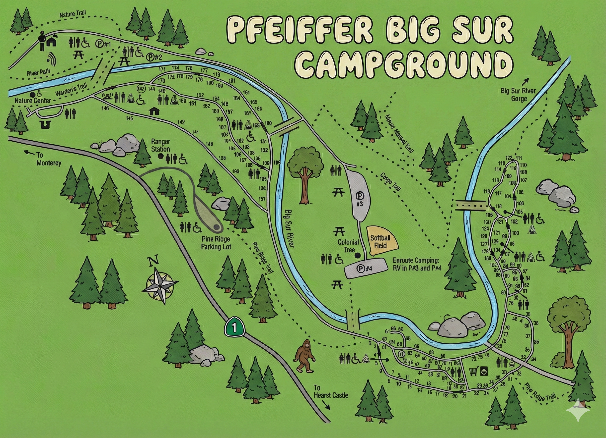
Pfeiffer Big Sur Campground Map Overview
The map is oriented with Highway 1 along the bottom and the Big Sur River looping through the center. A compass rose shows north pointing roughly up and left. The main campground road leaves Highway 1, crosses the river, and then splits into several loops of numbered campsites that stretch upstream toward the Big Sur River Gorge.
Site numbers run from the single digits near the entrance up into the 180s upstream. Several parking areas are marked as P#1, P#2, P#3 and P#4, and icons show restrooms, accessible toilets, water, picnic areas, and campfire circles.
Lower River Loop & Entrance Area
The first group of sites is a riverfront loop just past the bridge:
- Entrance / lower loop (sites 1–70s): After you cross the river from Highway 1, the road curls into a long loop following the Big Sur River. Sites in the 1–30 range occupy the lower part of the loop, with 40s–70s farther along the river bend.
- Restrooms and accessible icons cluster near the entrance area by sites 2–6 and again midway around the loop.
- The road eventually reconnects with the main park road, letting you continue upstream toward the upper campground.
These sites are the closest to Highway 1 and the Pine Ridge trailhead, and they tend to be the quickest to reach when you first arrive.
Upper River, Big Sur Station & High-Numbered Sites
Upstream from the entrance loop, the road follows the river and then climbs gently toward the nature center and higher sites:
- Big Sur Station area (sites ~130–160): Near Big Sur Station and the Nature Center, the map shows sites in the 130s–150s tucked between the road and river. Restrooms and accessible icons cluster near the nature center and station.
- Upper riverbank (sites 160s–180s): Continuing upstream, the road hugs the river with sites 160s–180s on the outside of the bend. A “River Path” and dotted Nature Trail run above these sites, with additional restrooms and picnic icons.
- Right-bank loop (sites 80s–120s): On the far right side of the map, across the river, a separate loop holds sites in the 80s–120s. Restrooms and accessible symbols appear in several clusters throughout this loop.
The high-numbered sites tend to be deeper in the forest and closer to trailheads for the Big Sur River Gorge and nearby ridge hikes.
Facilities & Symbols on the Map
Pfeiffer Big Sur uses a rich set of icons; the map makes it easy to see what’s near your site:
- Restrooms: Toilet icons spread along the river loops and near Big Sur Station and the nature center.
- Accessible restrooms: Restroom icons with accessibility symbols, often near parking areas.
- Picnic areas: Picnic-table icons along the river and near Colonial Tree and the softball field.
- Campfire center / amphitheater: Campfire symbols in the lower campground for evening programs.
- Parking lots: Marked as P#1, P#2, P#3, P#4, including lots for the Pine Ridge trailhead and en route RV camping.
- En route RV camping: Labeled near P#3 and P#4, separate from regular sites.
When choosing a site, use these clusters to decide how close you want to be to restrooms, day-use areas, and the busier trailheads.
Trails, Nature Center & Day-Use Spots
Dotted lines on the map highlight several short and long walks right from camp:
- Nature Trail & River Path: Loop above the upper campsites near the nature center, connecting picnic areas, restrooms, and viewpoints along the river.
- Pine Ridge Trail: Shown leaving the lower campground near Highway 1 and the Pine Ridge parking lot.
- Gorge Trail / Big Sur River Gorge: Dotted path from the right-bank loop leading toward the river gorge area.
- Colonial Tree & softball field: Labeled along the east side of the map near the en route RV parking and picnic icons.
The map also marks directions “To Monterey” along Highway 1 to the north and “To Hearst Castle” to the south, which helps anchor where you are along the Big Sur coast.
Pfeiffer Big Sur Campground Map FAQ
How are the sites arranged on the map?
Sites follow the Big Sur River in several loops, with low numbers near the entrance and higher numbers upstream and in the right-bank loop.
Does the map show restroom and water locations?
Yes. Restroom icons (including accessible restrooms) and water are spread along the river loops, near Big Sur Station, the nature center, and day-use areas.
Where do I park for hikes?
Parking areas labeled P#1–P#4 line up with trailheads like the River Path, Nature Trail, Pine Ridge Trail, and the route into Big Sur River Gorge.
Is there separate RV en route camping?
The map marks en route camping for RVs near P#3 and P#4, separate from the standard riverfront campsites.