Jenny Lake Campground Map, Grand Teton, Wyoming

Jenny Lake Campground Map
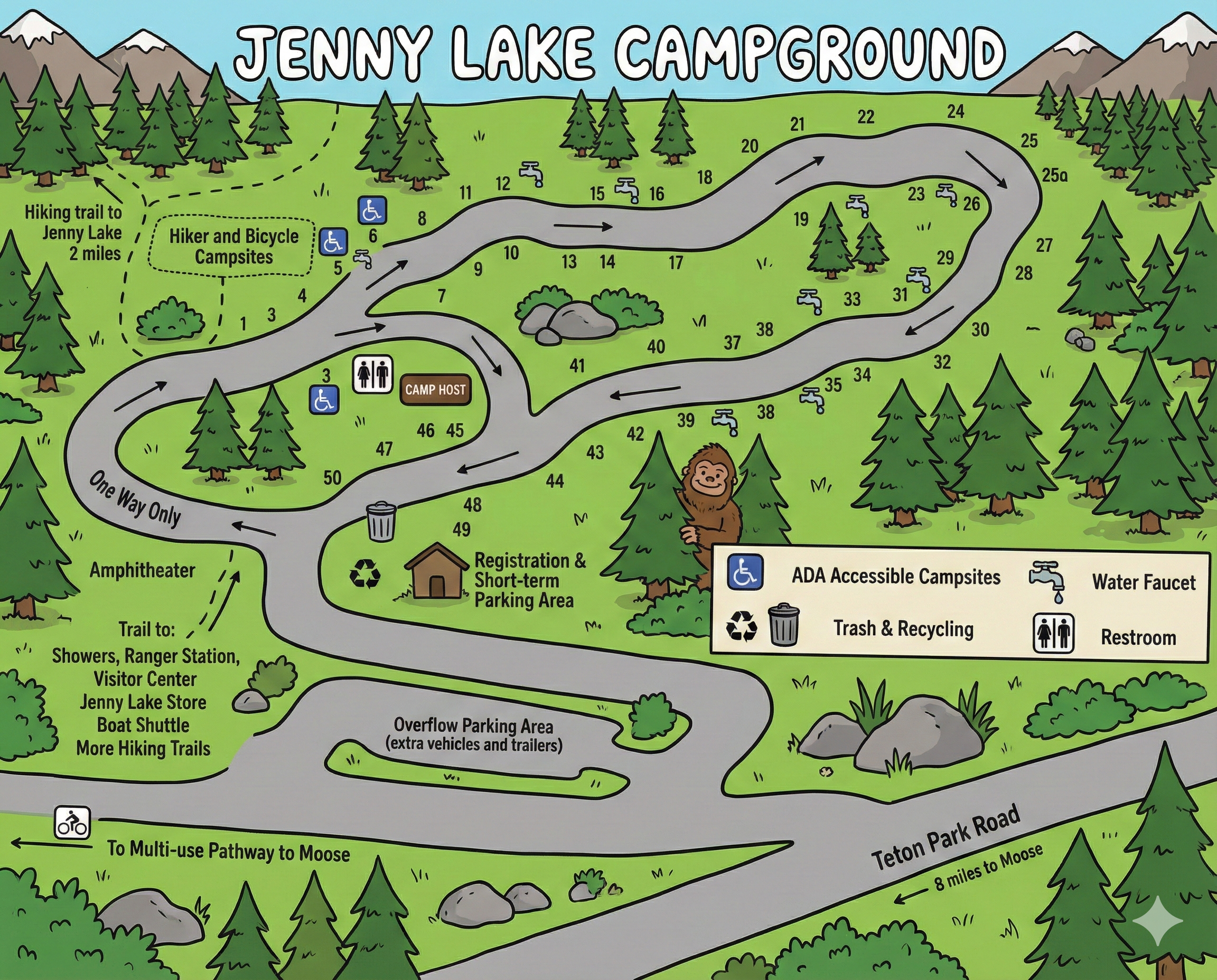
This page is a map-only guide to Jenny Lake Campground in Grand Teton National Park. It focuses on campsite numbering, one-way traffic flow, accessible sites, water faucets, restrooms, and how the campground connects to trails, parking, and nearby facilities.
Campground Layout & Traffic Flow
Jenny Lake Campground follows a single one-way internal road that loops through all campsites. Directional arrows on the map show the required driving flow, which helps reduce congestion during busy summer months.
The entrance and exit connect directly to Teton Park Road, with overflow parking and short-term parking shown near the registration area.
Campsite Numbers & Organization
Campsites are numbered sequentially along the loop. Numbers increase as you follow the one-way direction, making it easy to locate your site once you’re on the correct stretch of road.
- Lower-numbered sites: Located closer to the campground entrance and registration area.
- Mid-range sites: Wrap through the central curves of the loop near the camp host and restroom cluster.
- Higher-numbered sites: Found toward the far end of the loop before traffic returns toward the exit.
Site numbers are printed directly along the road edge on the map, so following the pavement line visually mirrors real navigation.
How to Read the Map Icons
- Restrooms: Marked near the camp host area and again farther along the loop.
- Water faucets: Shown at intervals along the campground loop.
- ADA accessible campsites: Clearly identified with accessibility icons.
- Trash & recycling: Clustered near the registration and mid-loop areas.
- Camp host: Labeled near the central portion of the campground.
Access, Parking & Nearby Trails
The map highlights several key connections beyond the campsites:
- Registration & short-term parking: Located near the campground entrance.
- Overflow parking: Designated for extra vehicles and trailers.
- Hiker & bicycle campsites: Grouped near the trail connection toward Jenny Lake.
- Trail access: Paths lead to the visitor center, ranger station, showers, Jenny Lake Store, boat shuttle, and additional hiking trails.
- Multi-use pathway: Provides a bike connection toward Moose.
Jenny Lake Campground Map FAQ
Is Jenny Lake Campground one-way?
Yes. The internal campground road is one-way, and the map arrows show the required direction of travel.
Does the map show accessible campsites?
Yes. ADA-accessible campsites are clearly marked with accessibility icons.
Where are restrooms and water located?
Restrooms and water faucets are marked at multiple points along the loop.
Can I walk to Jenny Lake from the campground?
Yes. The map shows a trail connection leading toward Jenny Lake and nearby visitor services.