Elkmont Campground Map at Great Smokey Mountains, tennessee

Elkmont Campground Map at Great Smoky Mountains
How the Elkmont Map is Oriented
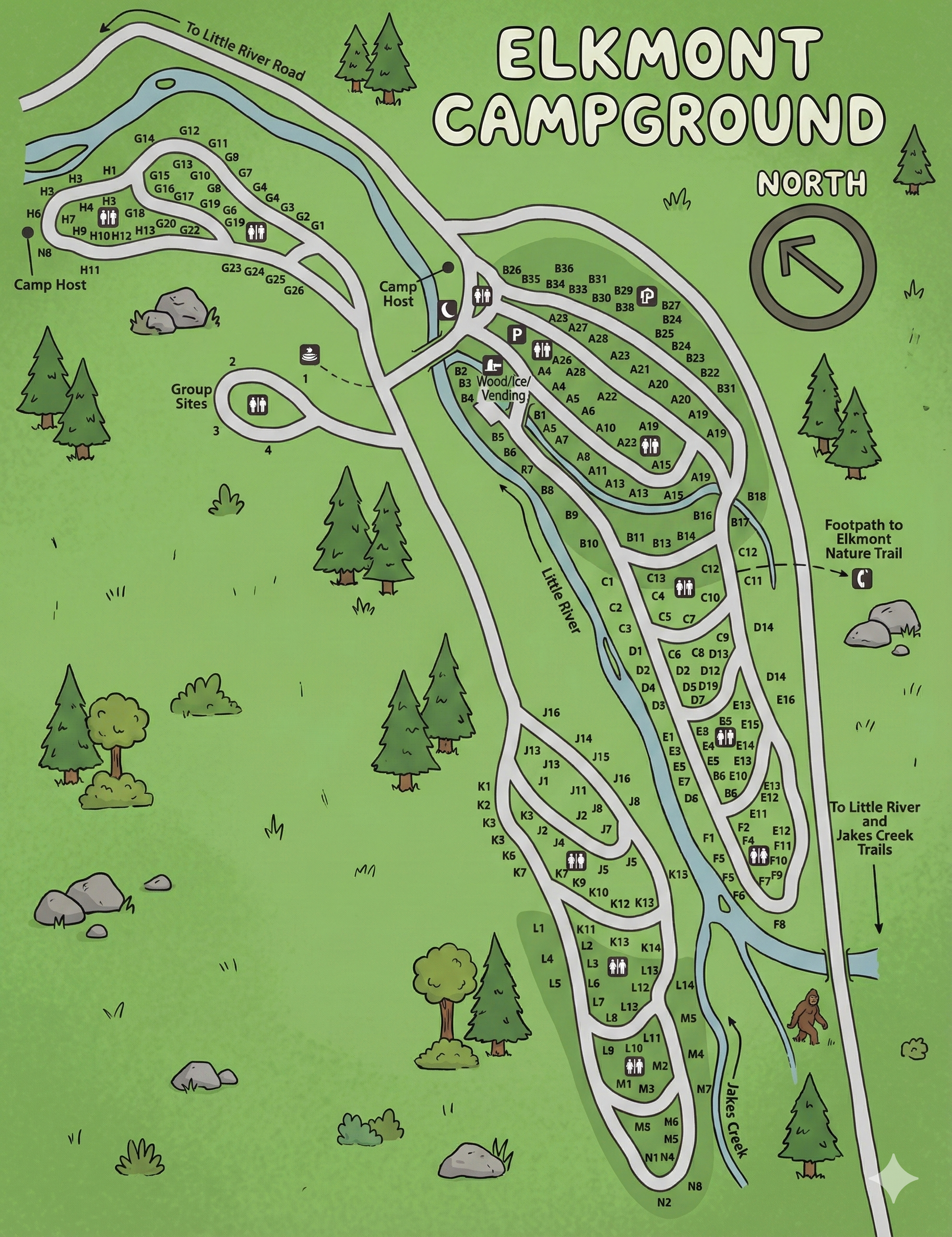
The map orients north toward the upper-right corner, marked by a large arrow. The loops stretch along the Little River on the right side and Jakes Creek toward the bottom, with the access road coming in from Little River Road at the top.
Campsites are grouped into lettered sections—B, C, D, E, F, G, H, J, K, L, M, and N—each with numbered pads. The gray shading in the center of the map highlights one of the main clusters of sites (B loop) around the bathhouse and wood/vending area, while other loops follow the riverbanks in long, narrow strands.
Loop Layout Along Little River & Jakes Creek
From the entrance near Little River Road, the campground road splits into several distinct sections:
- H Loop: At the far north-west, a small loop (H1–H18, G11–G19 nearby) with its own camp host and sites perched above the river.
- Group Sites: Just below H loop, a spur labeled Group Sites 1–4 forms its own mini-loop.
- B Loop: Central, shaded area with two camp host icons, the main restroom/bathhouse, and wood & vending—sites B1–B36.
- C, D & E Loops: Narrow, river-side clusters (C1–C12, D1–D14, E1–E17) hugging Little River on the upper-right side of the map.
- F Loop: A line of sites (F1–F12) along the right edge, closest to the “To Little River and Jakes Creek Trails” arrow.
- J Loop: Mid-camp stretch of sites (J1–J16) along Little River, between the upper and lower halves of the campground.
- K Loop: Another string of sites (K1–K7, K9–K15) on the inside of the road opposite J loop.
- L, M & N Loops: Lower loops along Jakes Creek, including L1–L14, M1–M7, and N1–N7, forming the southern end of the campground.
Roads are shown as pale gray bands; most sections are simple two-way spurs rather than complex ovals, so you generally drive to the end and turn around or loop back.
Group Sites & Camp Host Locations
Elkmont’s map makes the group area and camp host sites easy to spot:
- Group Sites 1–4: Loop off to the left just below H loop, each with a group icon and nearby restroom symbol.
- Camp Hosts: One host icon near H loop and another near the central B loop, so there’s host coverage for both the upper and mid sections of the campground.
If you’re camping with a larger group but not in a designated group site, choosing loops close to the host and bathhouse area can make coordination easier.
Facilities & Icons on the Elkmont Map
The key (usually printed with the original map) uses a small set of icons that appear throughout the loops:
- Restrooms/bathhouses: Toilet/shower icons near B loop, the group area, and several river-side loops.
- Wood & vending: Icon in the B loop cluster marking where you can buy firewood and basic supplies.
- Camp hosts: House icons at H loop and near B loop.
- Trash & recycling: Can symbols near main junctions so multiple loops can share the same bins.
When picking sites from the map, note how many sites away you are from restrooms and trash—especially if you’re in one of the longer strings along Little River or Jakes Creek.
Little River, Jakes Creek & Trail Access
The map labels both Little River (running down the middle-right) and Jakes Creek (bottom-right). Arrows note: “To Little River and Jakes Creek Trails” near F loop and “Footpath to Elkmont Nature Trail” near the upper loops.
River-side sites in the C, D, E, F, J, and parts of K loops back directly onto Little River, while the lower loops are a short walk to Jakes Creek. Dotted paths connect loops to these trailheads and riverside access points.
Elkmont Campground Map FAQ
Does the map show all loops and site numbers?
Yes. Loops B, C, D, E, F, G, H, J, K, L, M, and N are labeled, and each campsite is numbered along the roads and rivers.
Where are the group sites on the map?
Group Sites 1–4 appear on their own loop just below H loop, with a restroom icon nearby.
Can I see river and trail access?
The map labels Little River and Jakes Creek, and arrows point to the Elkmont Nature Trail plus the Little River
and Jakes Creek trailheads.
Where is the main bathhouse or wood/vending shown?
The central B loop includes icons for restrooms/bathhouse and wood & vending, making it the hub for many loops.