Watchman Campground Map at Zion National Park, Arizona
Watchman Campground Map at Zion
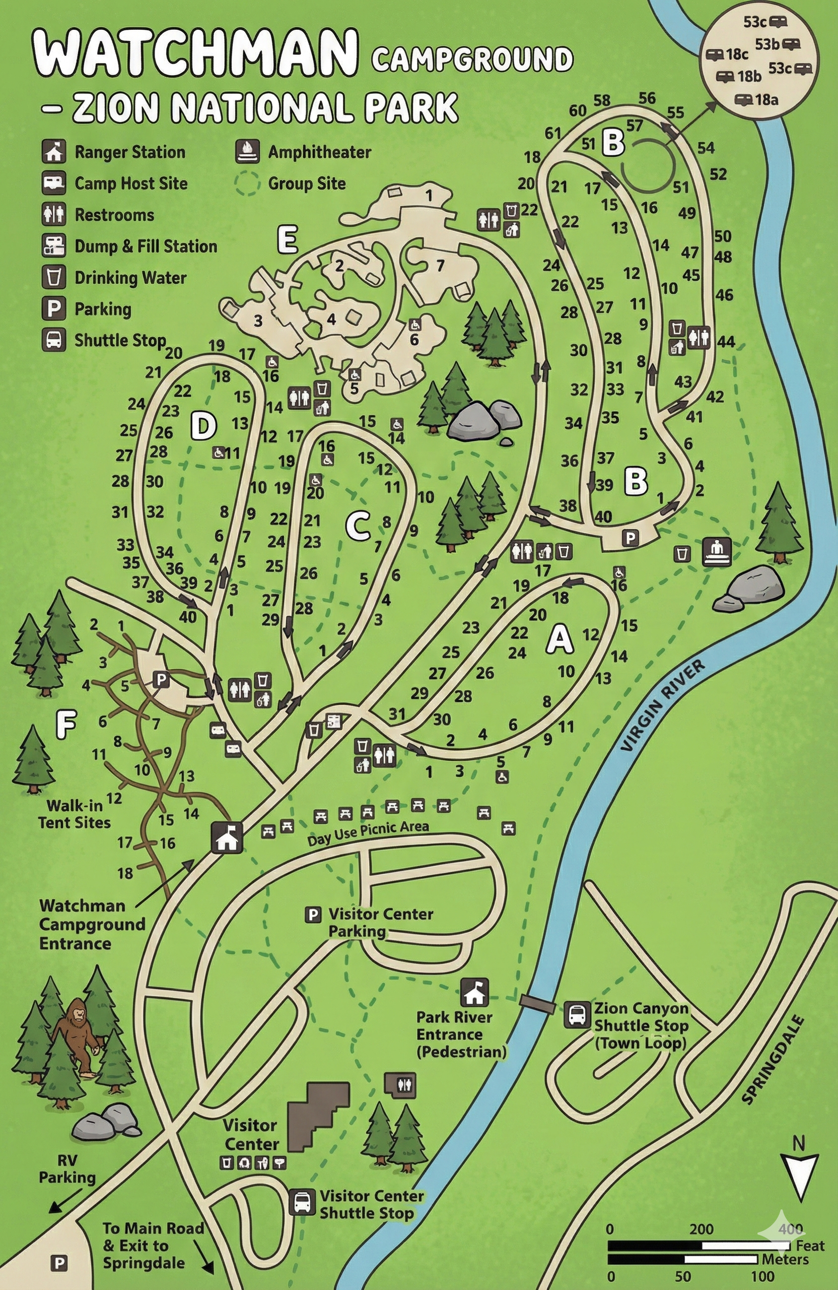
How the Watchman Campground Map is Organized
The map places Watchman Campground between the Virgin River and the main park entrance area. Campsites are grouped into loops labeled A, B, C, D, E, and F, each with numbered pads along light-gray roads. A legend in the upper left uses icons for restrooms, drinking water, trash bins, camp host sites, ranger station, dump & fill station, parking, picnic areas, trails, shuttle stops, the Watchman Amphitheater, and group sites.
Just below the campground loops you’ll see the Visitor Center, Visitor Center parking, day-use picnic area, shuttle stop, and the park river entrance footbridge that crosses the Virgin River toward Springdale’s town loop shuttle stop.
Loop-by-Loop Layout (A–F)
The vehicle loops stack uphill from the Virgin River, each forming a one-way oval or teardrop:
- Loop A: Lower-right loop near the river, with sites 1–31 wrapping around a restroom and trash cluster.
- Loop B: Two related ovals just north of A, with sites numbered into the 50s and 60s; several restrooms, drinking water, and trash icons sit along the outer curve.
- Loop C: Central loop tucked between loops A/D and the path network, with sites 1–30-ish and icons along its entrance road.
- Loop D: Long loop on the west side with sites 1–40; good if you want quick access back toward the campground entrance and walk-in area.
- Loop E: Cluster of short spurs at the north-west corner with sites 1–8 around a grove of trees and nearby picnic icons.
- Loop F: Small loop near the Watchman Campground Entrance, dedicated mainly to walk-in tent sites branching off a brown footpath network.
Black arrows marked on the roads show traffic direction; if you follow them, you’ll loop back to the main access road without needing tight U-turns.
Walk-In Tent Sites & Group Areas
On the lower-left of the map you’ll see a dedicated Walk-in Tent Sites area just off Loop F. Sites 1–18 are reached by footpaths rather than vehicle loops, with a nearby parking area marked by a P symbol.
The legend also includes a Group Site icon. Group sites are clustered near the central part of the campground (adjacent to the picnic and trail network) so larger parties share easy access to restrooms, water, and the Watchman Amphitheater.
If your permit or reservation is for a walk-in or group site, use the map to confirm whether you park in a nearby lot and walk in or drive directly to the pad.
Facilities & Icons to Watch For
The map legend packs a lot of useful information into a small icon set:
- Ranger station & camp host sites: Icons near the entrance and within the loops where staff or hosts are located.
- Restrooms: Toilet symbols scattered through every loop, often paired with drinking water and trash bin icons.
- Dump & fill station: Pump icon along the entrance road, useful for RVs arriving from or heading to Springdale.
- Parking & picnic areas: “P” icons and picnic table symbols around the day-use zone between the campground and Visitor Center.
- Watchman Amphitheater: Amphitheater icon north of the loops, reachable via the dotted trail network.
- Shuttle stops: Bus icons at the Visitor Center Shuttle Stop and the Zion Canyon Shuttle Stop (Town Loop) across the river.
When choosing or approaching your site, use restrooms, water, and trash icons as anchor points—they tell you how far you’ll walk for nightly routines.
Trails, River Access & Shuttle Connections
Green dashed lines on the map mark trails linking the campground to the picnic area, Visitor Center complex, and the footbridge crossing the Virgin River. From there, paths lead to the Zion Canyon Shuttle Stop (Town Loop) and into Springdale.
Inside the campground, these trails weave between loops B, C, D, and E, so you can walk to the river, amphitheater, or Visitor Center without moving your vehicle.
Watchman Campground Map FAQ
Does the map show every loop and site?
Yes. Loops A–F are labeled, and each campsite has a number next to the pad so you can follow them sequentially.
Where are the walk-in tent sites on the map?
The walk-in area is drawn near Loop F on the lower-left side, with numbered tent sites accessed by footpaths from a nearby parking area.
Can I see shuttle stops from the campground?
The legend marks shuttle stops at the Visitor Center and at the Zion Canyon Shuttle Stop (Town Loop) across the river, connected by trails and a pedestrian bridge.
Does the map show the dump station and amphitheater?
Yes. The dump & fill station icon sits along the entrance road, and the Watchman Amphitheater is labeled just north of the camping loops, reached by dotted trails.